Tuesday, September 16, 2008

Captivating Capiz


“Seafood Capital of the Philippines”

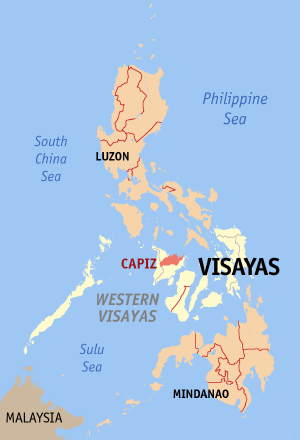
Capiz
is a province of the Philippines located in the Western Visayas region. Its capital is Roxas City and is located at the northeastern portion of Panay Island, bordering Aklan and Antique to the west, and Iloilo to the south.

Capiz faces the Sibuyan Sea to the north. Capiz is known for its mother-of-pearl shells that have the same name and are used for decoration, making lampshades, trays, window doors, etc.. Capiz is known for a popular local myth of Aswang, a generic name for ghouls, monsters and witches.

Capiz “Seafood Capital of the Philippines”, because of having a one of the highest contributors of aquamarine industry of the Philippines and swampy beside the sea the fishermen in the area can easily make it into pond for culturing fishes.

Farming and fishing are the primary sources of income of the people. The combined natural bounty of land and sea are enough to sustain a vibrant food industry. Its primary agricultural raw products are rice, corn, coconut, sugarcane, banana and cut flower. Apart from a surplus of agricultural products it generates every year, Capiz is also one of the country’s major suppliers of prawn and milk fish. Other agro-industrial harvests include blue marlin, squid, oysters, shrimp, seaweed, squid and angel wings. The rich fishing grounds attract investors to venture into prawn culture, prawn feed manufacture, seaweed farming and the distribution and processing of other marine products. It has a strong workforce of 445,246 with a literacy rate of 90.5% The agricultural sector makes the province one of the wealthiest in the Western Visayas Region although corruption has a high tendency to halt progress.

Its relatively unexplored caves are said to have high deposits of mineral resources such as limestone, gold and metal.

Monday, September 8, 2008

November: Scary?

Before the 1st day of November in last day of October, the night of that day is the HALLOWEEN celebration. Common Halloween activities include trick-or-treating, ghost tours, bonfires, costume parties, visiting "haunted houses", carving Jack-o'-lanterns, reading scary stories and watching horror movies. This practice is mostly done in America, in the Philippine some of the people having their own Halloween party.

On the next day is the All Saints day, the feast commemorates all those who have attained the beatific vision in heaven, while the next day, All Souls' Day, commemorates the departed faithful who have not yet been purified and reached heaven.

In Philippine culture, every All Souls day of the year the families of those who past aways go to the cemetery to clean the place and give flowers and lighting candle for remembering them and some are staying for a while to pray for the souls of their past aways. Some are reunited for them to see their special person remebering, they prepare food or should i say kakanin.

In the Philippines, if we say November, they say that this is the month of ghost. Mostly shows in TV every November is about ghost stories and some unnatural things. Some also said that November is a Days of scaryness but, this is not true. Being scared is only in the mind.

But november is one of my happiest day because our family will be having our reunion and we will having a a field trip and semestral break in or school. the nesxt month well be the December and if we talk about Decmber, its Christmas Holidays

Saturday, February 23, 2008

Survey: Why blogging?

Blogging: One way to earn money now a days, but does it really works? Blogging is one way of showing what you are or how you describe yourselves, what are your obserbations, reaction in a matter or thing, one way to critic or to reject something that you know that it is wrong or something to improve, your evryday life and experiences in your work or in a trip, school, vacation and other things that you are doing. Showing a new technologies, ideas and sharing thought or wisdom to others that you knew that it will help others. there are so many thing to express in blogging, your free to show anything under the sun.

Aside from this, the good news you can earn money as you writing or blogging. Now it is the new popular business in the world of internet. Do you want to earn also? There is no harm in trying but you should first take a little time to work on it. There are Many tips How to optimize you own site in the web. But if you knew that you experiences a hard time, don't be discourage, that is just a part of business just take it and it will mold you to be a better person or a blogger.I hope that this one helped you.

Friday, February 15, 2008

Pace Factor


The pace factor is determined by getting the product of the sum of steps by the known value of the the line or course. From getting the pace factor by pace or one step, or by the stride or double step, you can use your own pace factor to measure a line or a course.

Sunday, February 10, 2008

Sunday, January 27, 2008

DEVELOPMENT OF SURVEYING INSTRUMENT

Surveying instruments were developed gradually. It is believed that, an extensive use of surveying instruments came about during the early days of the Roman Empire. This re­markable engineering ability of Romans is clearly demons­trated by their extensive construction of structures and buildings which continue to exist even up to this modern era. It will be noted that many surveying instruments and devices evolved from those which were earlier used in astronomy. The following instruments were the early forerunners of our present-day surveying instruments.


  • Astrolabe. The astrolabe of Hipparchus is consider­ed to be one of the best known of the measuring instruments that have come down from ancient times. It was developed sometime in 140 B.C., and further improved by Ptolemy. The instrument had a metal circle with a pointer hinged at its center and held by a ring at the top, and a cross staff, a wooden rod about 1.25 meters long with an adjustable cross arm at right angles to it. The known length of the arms of the cross staff allow distances and angles to be determined by proportion. It was originally designed for determining the altitude of stars.


  • Telescope. The invention of the telescope in. 1607 is generally accredited to Lippershey. In 1609, Ga1ileo cons­tructed a refracting telescope for astronomical observa­tions. However, it was only when cross hairs for fixing the line of sight were introduced, that the teles­cope was fixed in early surveying instruments.


  • Transit. The invention of the transit is credited to Young and Draper who worked independently from each other sometime in 1830. Both men were able to put together in one instrument the essential parts of what has long been known as the universal surveying instrument.


  • Semicircumferentor. An early surveying instrument which was used to measure and layoff angles, and establish lines of sight by employing peep sights.


  • Plane Table. One of the oldest types of surveying instruments used in field mapping. It consists of a board attached to a tripod in such a way that it can be leveled or rotated to any desired direction.


  • Dioptra. The dioptra, which was perfect­ed by Heron of Alexandria, was used in leveling and for measuring horizontal and vertical angles. It consists es­sentially of a copper tube supported on a standard and could be rotated in either a horizontal or vertical plane. For measuring horizontal angles, a flat circular disc with graduations in degrees is used. An arm containing sighting apertures at either end could be rotated to any desired position on the disc.


  • Roman Groma. The Roman surveyors used the groma instrument for aligning· or sighting as an points. It consisted basically of cross arms fixed at right angles and pivoted eccentrically upon a vertical staff. Plumb lines were suspended from the ends of the arms. By employing the groma two lines at right angles to each other could be established on the ground where it is set up.


  • Libella. The Assyrians and Egyptians are believed to be the first users of the libella.The instru­ment had an A-frame with a plumb line suspended from its apex and was used to' determine the horizontal. Archeolo­gists are of the belief that the horizontal foundations of the great pyramids of Egypt were probably defined by this device.


  • Vernier. The vernier is a short auxiliary scale placed alongside the graduated scale of an instru­ment, by means of which fractional parts of the smallest or least division of the main scale can be determined precise­ly without having to interpolate. It was invented in 1631 by a Frenchman name Pierre Vernier. Surveying instruments employ either a direct or retrograde vernier.

  • Diopter. An instrument developed by the Greeks sometime in 130 B.C., and known to be their most famous surveying instrument. The diopter was used for leveling, laying off right angles, and for measuring hori­zontal and vertical angles. Since the telescope was not yet invented during the time the diopter was used, peep sights were employed for sighting and in aligning the device.


  • Compass. The magnetic compass came into wide use during the 13th century for determining the direc­tion of lines and in calculating angles between lines. It was first introduced for use in navigation. The compass consists of a magnetized steel needle mounted on a pivot at the center of a graduated circle. The needle continues to point toward magnetic north and gives a reading which is dependent upon the position of the graduated circle.

  • Gunter"s Chain. The Gunter's chain, which was invented by Sir Edmund Gunter in 1620, was the forerunner of instruments dsed for taping distances. It is 66 ft long and contains 100 links, so that distances may be recorded in chains and in decimal parts of the chain. Each part, called a link, is 0.66 ft or 7.92 inches long.


  • Chorobates. This instrument was designed for le­veling work. It consisted of a horizontal straight-edge about 6 meters long with supporting legs, and a groove 2.5 cm deep and, 1.5m long on top. Water is poured into the groove and when the bar is leveled so that water stood evenly in the groove without spilling, a horizontal line is established.


  • Merchet. The merchet was a device for measuring time and meridian. It was first used by the Chaldeans in about 4,000 B.C. It consisted of a slotted palm leaf through which to sight and a bracket from which a plumb bob was suspended. -By sighting through the 'slot and past the plumb bob string, a straight line could be projected.

Sunday, January 20, 2008

BRANCHES OF SURVEYING

  • Cadastral Survey - Are usually closed surveys which are under taken in urban or rural locations for the purpose of determining the property lines, boundaries, corners and areas.

  • City Survey - are surveys of the areas and near the city for the purpose of planning, expansion or improvement.

  • Construction Survey - Undertaken at a construction site to provide data for preparing plans and specifications.

  • Hydrographic Survey - reffer to surveying streams, lakes, harbors or bodies of waters important to navigatio and building od dams, canals, irrigations and facilities.

  • Industrial Survey - sometimes known as optical tooling, it refers to surveying areas possible to construction of industrial plants/building.

  • Mine Survey - refers to surveying in determining the position of all underground activities.

  • Photogrammetric Survey - type of survey which makes use of photograph taken with cameras either in the air or in the ground.

  • Route Survey - the survey of possible location of highways, bridges, tunnels, railroads, etc.

  • Topographic Survey - made for the location of elevation of nautal or man-made terrain, it also determine the location of plane.

Friday, January 11, 2008

Elementary Surveying

INTRODUCTION
  1. Surveying - may be defined as the art of making measurements of recative positions of namral, man-made feature on the earths surface and the representation of the infromation either in graphically or numerecally.

  • TWO GENERAL CLASSIFICATION OF SURVEYING
  1. Plain Surveying - is the type of surveying in which the earth is consedered flat surface and where the distance is in limited extent and the exact shape of the earht is disregard.

  2. Geodetic Surveying - is a type of surveying that is in wide extent in which it takes into account the spheroidal shape of the earth.

search

Custom Search
Powered By Blogger