- Astrolabe. The astrolabe of Hipparchus is considered to be one of the best known of the measuring instruments that have come down from ancient times. It was developed sometime in 140 B.C., and further improved by Ptolemy. The instrument had a metal circle with a pointer hinged at its center and held by a ring at the top, and a cross staff, a wooden rod about 1.25 meters long with an adjustable cross arm at right angles to it. The known length of the arms of the cross staff allow distances and angles to be determined by proportion. It was originally designed for determining the altitude of stars.

- Telescope. The invention of the telescope in. 1607 is generally accredited to Lippershey. In 1609, Ga1ileo constructed a refracting telescope for astronomical observations. However, it was only when cross hairs for fixing the line of sight were introduced, that the telescope was fixed in early surveying instruments.
- Transit. The invention of the transit is credited to Young and Draper who worked independently from each other sometime in 1830. Both men were able to put together in one instrument the essential parts of what has long been known as the universal surveying instrument.


- Semicircumferentor. An early surveying instrument which was used to measure and layoff angles, and establish lines of sight by employing peep sights.

- Plane Table. One of the oldest types of surveying instruments used in field mapping. It consists of a board attached to a tripod in such a way that it can be leveled or rotated to any desired direction.

- Dioptra. The dioptra, which was perfected by Heron of Alexandria, was used in leveling and for measuring horizontal and vertical angles. It consists essentially of a copper tube supported on a standard and could be rotated in either a horizontal or vertical plane. For measuring horizontal angles, a flat circular disc with graduations in degrees is used. An arm containing sighting apertures at either end could be rotated to any desired position on the disc.
- Roman Groma. The Roman surveyors used the groma instrument for aligning· or sighting as an points. It consisted basically of cross arms fixed at right angles and pivoted eccentrically upon a vertical staff. Plumb lines were suspended from the ends of the arms. By employing the groma two lines at right angles to each other could be established on the ground where it is set up.

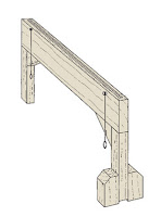
- Libella. The Assyrians and Egyptians are believed to be the first users of the libella.The instrument had an A-frame with a plumb line suspended from its apex and was used to' determine the horizontal. Archeologists are of the belief that the horizontal foundations of the great pyramids of Egypt were probably defined by this device.
- Vernier. The vernier is a short auxiliary scale placed alongside the graduated scale of an instrument, by means of which fractional parts of the smallest or least division of the main scale can be determined precisely without having to interpolate. It was invented in 1631 by a Frenchman name Pierre Vernier. Surveying instruments employ either a direct or retrograde vernier.
- Diopter. An instrument developed by the Greeks sometime in 130 B.C., and known to be their most famous surveying instrument. The diopter was used for leveling, laying off right angles, and for measuring horizontal and vertical angles. Since the telescope was not yet invented during the time the diopter was used, peep sights were employed for sighting and in aligning the device.

- Compass. The magnetic compass came into wide use during the 13th century for determining the direction of lines and in calculating angles between lines. It was first introduced for use in navigation. The compass consists of a magnetized steel needle mounted on a pivot at the center of a graduated circle. The needle continues to point toward magnetic north and gives a reading which is dependent upon the position of the graduated circle.
- Gunter"s Chain. The Gunter's chain, which was invented by Sir Edmund Gunter in 1620, was the forerunner of instruments dsed for taping distances. It is 66 ft long and contains 100 links, so that distances may be recorded in chains and in decimal parts of the chain. Each part, called a link, is 0.66 ft or 7.92 inches long.


- Chorobates. This instrument was designed for leveling work. It consisted of a horizontal straight-edge about 6 meters long with supporting legs, and a groove 2.5 cm deep and, 1.5m long on top. Water is poured into the groove and when the bar is leveled so that water stood evenly in the groove without spilling, a horizontal line is established.
- Merchet. The merchet was a device for measuring time and meridian. It was first used by the Chaldeans in about 4,000 B.C. It consisted of a slotted palm leaf through which to sight and a bracket from which a plumb bob was suspended. -By sighting through the 'slot and past the plumb bob string, a straight line could be projected.


